Field Dispatch: The Nazca Lines Might Be a Map of What’s Underground
The world’s most famous desert drawings may not have been made for the sky. They may have been made for the water beneath the dirt.
Here is something that will rearrange the way you think about the Nazca Lines.
Everybody knows the drawings. The hummingbird. The spider. The monkey with the coiled tail. Enormous figures scraped into a desert plateau in southern Peru, visible only from the air, made by a civilization that couldn’t fly. They’ve generated a century’s worth of theories — astronomical calendars, alien landing strips, ceremonial pathways, offerings to sky gods. All of them attempt to answer the same question: why would anyone draw pictures that can only be seen from above?
But the famous animal figures — the ones on every postcard, every documentary thumbnail — represent a tiny fraction of what’s actually out there. The Nazca pampa contains over a thousand geoglyphs. Most of them aren’t animals at all. They’re geometric. Huge trapezoids, some hundreds of metres long. Perfectly straight lines extending for kilometres across the plateau. Triangles. Rectangles. Zigzag patterns. These shapes vastly outnumber the figurative drawings, and they’ve received a fraction of the attention because they don’t photograph as well on a coffee-table book.
In 1996, a researcher named David Johnson was hiking the Nazca Valley studying water sources — not the lines. He was mapping where the underground aquifers ran, tracing the geological faults that channelled snowmelt from the Andean foothills down through the valley’s subsurface. And he noticed something that, as far as he could tell, nobody had pointed out before.
The giant trapezoids kept appearing directly above the aquifers.
Not just near them. Above them. The wide end of a trapezoid would sit over the
What you need to understand about the Nazca desert
The Nazca region receives less than 25 millimetres of rain per year. That’s less than the Gobi Desert. Less than Death Valley. The rivers that cross the drainage are seasonal and unreliable — some years they barely flow at all. The Andes are right there, a wall of mountains visible from the pampa on a clear day, and snowmelt runs down from them in underground channels. But it runs underground. On the surface, there’s almost nothing.
The Nazca civilization flourished here for roughly 800 years, from about 200 BCE to 600 CE. At its peak, the population reached an estimated 25,000 people. They built a ceremonial complex at Cahuachi — adobe pyramids, plazas, pilgrimage centres — whose core covered about 150 hectares, with archaeological remains scattered across a much wider area of the valley. They produced some of the finest polychrome pottery in the pre-Columbian world.
And they did all of it in a place where, if you don’t know where the water is, you die.
This is the part of the story that most Nazca Lines documentaries skip. The civilization’s survival depended entirely on an intimate, precise knowledge of subsurface hydrology — knowing not just where water existed underground, but how it moved, where the faults and permeable gravel layers channelled it, where it could be accessed, and where it couldn’t. This wasn’t abstract knowledge. It was the difference between a living settlement and a dead one.broadest section of a water-bearing fault zone, and the narrow end would point toward the fault’s source in the foothills. Straight lines — the ones that run for miles across the pampa — seemed to trace the paths of faults that conducted water from the mountains into the valley. Zigzag lines appeared at the boundaries of aquifers, marking where the water stopped and dry ground began.
Johnson teamed up with Stephen Mabee, a hydrogeologist at the University of Massachusetts, and Donald Proulx, an archaeologist who’d spent decades studying the Nazca. Together, they set out to test a simple hypothesis: the Nazca Lines are a map. Specifically, a map of the underground water system that kept an entire civilization alive in one of the driest landscapes on Earth.
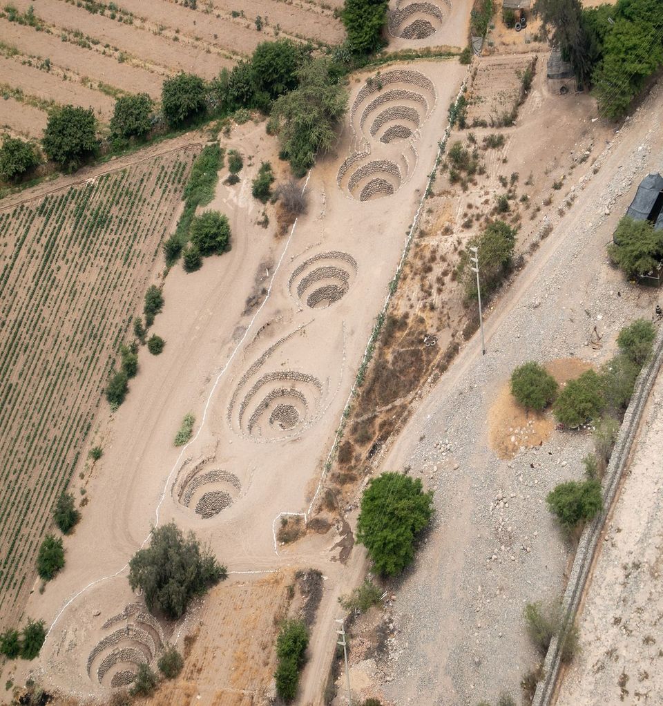
The Puquios
The Nazca didn’t just find water. They engineered a system to move it.
Starting around 500 CE — possibly earlier, the dating is genuinely difficult because you can’t carbon-date river cobbles — they constructed a network of underground aqueducts called puquios. The word comes from Quechua: pukyu, meaning spring or water source.
A puquio works like this. You identify where the water table is accessible, usually in the higher ground near the Andean foothills. You dig down to the aquifer. Then you build a horizontal tunnel, roughly a metre square, lined with smooth river cobbles laid without mortar, that slopes gently downhill toward where the water is needed. Sometimes for miles. The water flows by gravity through the stone-lined channel until it surfaces through open trenches into small reservoirs where it can be used for drinking, washing, and irrigation.
Spaced along the underground route are vertical shafts that open at the surface as distinctive spiral-shaped funnels. The Spanish called them ojos — eyes. For decades, archaeologists assumed they were maintenance access points, like manholes. Then in 2012 and 2016, Rosa Lasaponara and Nicola Masini at the Italian National Research Council used satellite imaging to map the full puquio system and proposed that the spirals actually function as wind-driven pumps. The corkscrew shape funnels wind down into the tunnels, generating pressure differentials that help push water through the channels and keep it oxygenated.
Gravity and wind. No moving parts. No fuel. No maintenance beyond periodic cleaning of the channels.
More than 40 of these systems have been documented. At least 36 are still functioning today, still delivering fresh water in the valleys around Nazca. The best-known are the Cantalloc aqueducts, about four kilometres outside the modern city. You can walk right up to them. The water is clear. It tastes clean. It has been running for fifteen hundred years.
The Map Hypothesis
So Johnson had a hunch. Then Mabee brought the instruments.
When the UMass team began systematically mapping the Nazca Valley — plotting aquifers, faults, puquios, geoglyphs, and ancient settlement sites — a spatial pattern emerged. In at least five locations, wells and aquifers corresponded directly with geoglyphs and archaeological sites. The settlements weren’t random. Communities had been established precisely where the underground water system delivered its output. And the geoglyphs, particularly the geometric ones, seemed to track the underground infrastructure.
Johnson proposed a specific grammar. Trapezoids indicated the width and direction of a water-bearing fault zone. Straight lines traced the path of an aquifer or a fault conducting water into the valley from the mountains. Zigzag lines marked the edges — the aquifer’s boundaries, where water stopped and barren ground began. If you knew how to read the shapes, you could navigate the invisible hydrology beneath your feet.
Mabee put it plainly in a Discover profile of the project. Modern engineers map their water lines, he said. Maybe the Nazca did the same thing — they just drew the map on the ground.
It’s a hard idea to dismiss once you hear it. In a landscape where water is life and the water is invisible — running ten, fifteen metres below the surface through faults and gravel layers you can’t see — you would absolutely want a map. And if you didn’t have paper, or writing, or any recording technology beyond what your hands could do to the surface of the earth, you might draw the map at full scale, right on the ground, using the only medium that would survive in a desert where nothing rots: stone.
The Complications
This is the part where I have to be honest about what the data actually shows.
Johnson originally located his aquifer sources using dowsing — a technique that has no scientific support. This doesn’t invalidate his geological observations, which were independently confirmed by Mabee’s team using standard geophysical methods. But it gave his critics an easy target and made the academic establishment understandably cautious.
More significantly, when Mabee’s graduate student Gregory Smith conducted a rigorous statistical analysis comparing the orientation of geoglyphs with the trend of geological lineaments and faults, the correlation was not statistically significant. Smith’s conclusion, published in 2003, was that any alignment between geoglyphs and faults appeared to be coincidental.
That’s a serious finding. It doesn’t kill the hypothesis outright — five cases of direct spatial correspondence between geoglyphs, aquifers, and settlement sites is hard to dismiss — but it means the simple version of the theory (all the lines are water maps) doesn’t hold. The relationship, if it exists, is partial. Some of the geometric geoglyphs may track underground water. Others almost certainly don’t.
Katharina Schreiber, who has studied the Nazca puquios for decades, noted that Johnson’s methodology tended to work backward: he would find a fault, then find a trapezoid pointing to it, rather than using the trapezoids to predict where water should be. Six of the 39 puquios she studied appeared to derive their water from faults on the valley sides. Most of the rest drew from underground river channels directly beneath the riverbed — a different mechanism entirely.
And then there’s the sheer intricacy of the lines themselves. The figurative drawings — the spider, the hummingbird, the whale — don’t map neatly onto hydrological features. They seem to belong to a different programme. One that’s more symbolic, more ritual, more concerned with the forces that controlled water than with the plumbing that delivered it.
So where does that leave us? Johnson identified a real spatial relationship between some geoglyphs and some aquifers. The relationship is not universal, and it is not statistically robust across the full dataset. But the correlation in specific locations is genuine, and the broader point — that the Nazca understood their underground hydrology with extraordinary precision and built their entire society around it — is not in dispute.
What The Satellite Work Revealed
Lasaponara’s research, published in Ancient Nasca World: New Insights from Science and Archaeology, added a layer that neither Johnson nor his critics had access to in the late 1990s.
Using satellite imagery, her team mapped not just individual puquios but the entire distribution system across the Nazca drainage. They identified previously unknown puquios. They traced connections between the underground channels and nearby settlements, providing stronger evidence for the pre-Hispanic dating of the system — some scholars, notably Monica Barnes and David Fleming, had argued the Spanish built them, but the settlement patterns don’t support that. Communities appear to have been established specifically where the puquios delivered water, centuries before the Spanish arrived.
Lasaponara also suggested a direct connection between the puquio system and Nazca Lines, though her published conclusions were cautious. The geoglyphs and the aqueducts, she argued, were products of the same civilisation, the same knowledge base, the same existential relationship with underground water. Whether the lines literally mapped the water or ritually invoked it — or both — remained an open question.
And then, in 2024, a team from Japan’s Yamagata University, working with IBM, used artificial intelligence to identify 303 previously unknown geoglyphs on the Nazca pampa. Many of the new figures are small — less than ten metres — and depict animals, humanoids, and ceremonial scenes. The full landscape is vastly more marked-up than anyone had realised. We’re still cataloguing what’s there. The idea that we’ve settled what the lines mean is, at this point, a bit premature.
Why This Matters Beyond Archaeology
I keep coming back to one detail.
The Nazca civilisation began declining around 500 CE. By 750 CE it was gone. The most widely accepted explanation involves a combination of extended drought, El Niño flooding, and deforestation — the Nazca cleared their native huarango trees (Prosopis pallida) to make room for maize and cotton. The huarango was an ecological keystone. Its root system stabilised the soil, prevented erosion, and helped regulate the local water table. When the trees went, the landscape became vulnerable. When the floods came, the irrigation infrastructure washed out. When the droughts followed, there was nothing left to fall back on.
The ceremonial centre at Cahuachi was deliberately abandoned around 500 CE. The people sealed the pyramids and covered them with sand, as though performing a closing ritual. No signs of violence. No invasion. They simply stopped, buried their sacred buildings, and walked away. The number of geoglyphs being created appears to have increased during this period — as if the urgency of the drawings grew in proportion to the desperation.
More drawings. More prayers. Less water.
The puquios survived. Thirty-six of them are still running. The technology outlasted the civilisation that built it. The water still flows through stone-lined tunnels beneath a desert where the people who understood the system — who may have drawn the largest map ever made to record what they knew — are fifteen centuries gone.
I don’t know if the Nazca Lines are a water map. The evidence is partial and contested and honest researchers disagree. But I know the Nazca understood their underground water system with a precision that most modern hydrologists would respect. I know they built infrastructure to capture it that still works today. And I know that the drawings on the surface and the engineering beneath it came from the same civilisation, the same minds, the same desperate negotiation with a landscape that could kill you if you lost track of what was flowing underneath.
The Lines are magnificent. But the water is what kept people alive. And the question of whether one was a diagram of the other is, to me, one of the most interesting unsolved problems in archaeology.
Fifteen hundred years after the Nazca disappeared, their water is still running. The connection between sacred sites and what's moving underground is the thread that runs through every chapter of The Places That Speak — and the Nazca aren't the only civilization that drew their most important marks directly above it. You can always read the dispatches without signing up. But if you want to know when new ones land and get The Map — an interactive guide to every site in the investigation and dozens more that share the same geology — it's free.
Image Attribution: Aerial view of the spiral ojos (eyes) along the Cantalloc puquios near Nazca, Peru. Photo: PsamatheM, via Wikimedia Commons. Licensed under Creative Commons Attribution-ShareAlike 4.0 International (CC BY-SA 4.0).